

Tools & Technology
RV Manumā
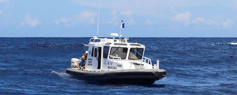
National Marine Sanctuary of American Samoa currently operates one vessel in support of research and monitoring, education, and emergency response. The R/V Manumā is a multi-purpose research vessel designed primarily to support sanctuary science and education missions. It also supports researchers from the National Park Service, American Samoa Department of Marine and Wildlife Resources, and other sanctuary partners.
This rigid-hull inflatable has an overall length of 33 feet, and beam of 10.5 feet. It has twin 200 horsepower outboard engines, a fuel capacity of 200 gallons, and a range of 65 to 80 nautical miles. It carries a crew of two to three and a science party of five to seven for single-day trips. Since it was acquired in 2009, the vessel has served as a platform for research and monitoring from diving operations to benthic habitat mapping, and for regional damage assessments and recovery efforts. It is the only NOAA vessel dedicated to marine research in the territory.

Ocean Acidification Buoy
Located just past the reef in Fagatele Bay floats a MAPCO2 buoy which provides information about water quality such as temperature, salinity, turbidity, chlorophyll, air pressure, and pH. Together, these readings allow scientists to monitor water quality and major threats to the reef, including ocean acidification. The MAPCO2 scientific buoy at Fagatele Bay makes National Marine Sanctuary of American Samoa the only "NOAA Class III" site in the Southern Hemisphere, having the highest level of coral reef monitoring provided through NOAA. All data collected from the buoy can be viewed online via NOAA’s Pacific Marine Environmental Laboratory and the Pacific Islands Ocean Observing System (PacIOOS).
Sound Monitoring and Sound Traps
An ecological acoustic recorder (EAR) was deployed at Fagatele Bay in October 2019 to build a baseline of acoustic data, including vocalizations by humpback whales, spinner dolphins, and ambient sounds of fish and invertebrates, such as snapping shrimp, to evaluate activity in the sanctuary. The EAR was provided on loan by Ocean Science Institute, in partnership with Hawaiian Islands Humpback Whale National Marine Sanctuary. Along with data collected from the CO2 buoy, data from the EAR is helpful in building up comprehensive data for Fagatele Bay for long term monitoring. During the 2025 field season, Sound trap S600 hydrophone will be deployed to continue collecting ecological acoustic data from Fagatele Bay.
The U.S. Navy has partnered with NOAA to understand the role and impacts of sound in the National Marine Sanctuary System and beyond. These sounds include those produced by animals, humans, and natural processes such as wind and wave action. See the research already underway as a part of this initiative on SanctSound.
Remotely Operated Vehicle
The reefs within the Sanctuary extend far past the iconic sites accessible by snorkel and SCUBA diving. At sites where it is too deep for scientists to safely dive, a remotely operated vehicle (ROV) can be deployed, allowing us access to the mesophotic zone. Though mesophotic reefs provide a unique and crucial habitat for fish, corals, sponges, and invertebrates, their depth has limited the information known about them, and thus our ability to monitor and conserve them. Our ROV, the Deep Trekker Revolution, uses high resolution cameras and advanced sensors to collect precise, real-time data that would be otherwise inaccessible to divers. Through a process called photogrammetry, it is possible to use photos captured by the ROV to construct a 3D model of the reef, allowing for a more detailed analysis of the reef’s composition.
Exploration Technology Made Possible by Partners
Drix
Uncrewed surface vehicle (USV) DriX is a hybrid remote-controlled/autonomous seafloor mapping platform and communication relay. DriX is operated by CCOM/JHC at the University of New Hampshire in partnership with the Ocean Exploration Cooperative Institute and E/V Nautilus. During E/V Nautilus’ NA164/5 expedition to American Samoa, E Mamana Ou Gataifale, DriX was used to map Vailulu’u.
Mesobot
Developed by Woods Hole Oceanographic Institute (WHOI), Mesobot is an ROV designed to study the mesopelagic, or twilight, zone. Mesobot’s impressive battery life allows it to observe and sample the water column for up to forty-eight hours. Nautilus and WHOI’s partnership made it possible for Mesobot to be aboard for NA164/5.
DAP Lander
The Deep Autonomous Profiler (DAP) Lander is designed to collect water samples strategically throughout the water column to investigate changes in chemical composition and biological communities. A partnership between Nautilus and the University of Rhode Island made it possible to include the DAP Lander on expedition NA164/5.
ROVs Hercules and Atalanta
Working as a team, ROV Hercules and Towsled Atalanta are deployed together and can reach depths of up to 4,000 meters (13,100 feet). Hercules is equipped with several sensors, two manipulator arms, a high resolution camera, and mapping tools which allow it to collect a myriad of samples on dives. Hovering several meters above Hercules, Towsled Atalanta provides an aerial view of Herucles’ activities. Atalanta also acts as a buffer between the ship tether and Hercules, allowing for smoother navigation.